Swap the Bole espresso for a sunrise on the "Roof of Africa." In Simien Mountains National Park, 1,500-meter cliffs and Gelada monkeys guard the legendary "Chessboard of the Gods." From Gondar logistics to the summit of Ras Dashen, start your journey here—the essential source for trekking in Ethiopia.
The first sound of a Simien morning is not the wind, nor the crackle of a cook’s fire, but a complex, gurgling chatter that mimics the cadence of human speech. It begins as a low murmur from the basalt ledges where the Gelada monkeys huddle for warmth against the night’s frost.1 As the sun crests the jagged horizon of the Ethiopian Highlands, this chatter swells into a symphonic chorus of chirps, grunts, and liquid trills. This is the herald of the high plateau—a sensory awakening that signals the start of a journey into one of the most dramatic landscapes on the planet.
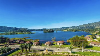
For the traveler sitting in a sleek café in Addis Ababa’s Bole district, nursing a macchiato and watching the city’s rapid ascent toward modernity, the Simien Mountains National Park feels like another world entirely.4 Yet, the transition from the urban thrum of the capital to the ancient stillness of the north is the definitive Ethiopian experience. AddisToday.com serves as the bridge for this transition, moving the explorer from the world of Italian-influenced espresso culture to the raw, vertical wilderness of the "Chessboard of the Gods".4 This report analyzes the geological, biological, and logistical frameworks that define the Simien massif, establishing it as the premier trekking destination for those seeking to understand the true scale of the African continent.
The Chessboard of the Gods
The Simien Mountains are not merely hills; they are massive basalt towers, the remnants of a volcanic shield that dominated the Horn of Africa millions of years ago. To understand this landscape, one must look back to the Oligocene epoch, approximately 40 to 25 million years ago, when the earth’s crust fractured and unleashed thick layers of basaltic lava. These eruptions were not the explosive events of popular imagination but a relentless pouring out of molten rock that built a plateau several kilometers thick.
Over the ensuing millennia, tectonic shifts associated with the formation of the Great Rift Valley tilted this massif, and the forces of erosion began their slow, patient sculpture. Water, ice, and wind have carved the plateau into a labyrinth of deep precipices and jagged peaks.6 The escarpment stretches for miles, with sheer cliffs that drop over 1,500 meters into the lowlands, creating a landscape so chaotic and grand that early explorers dubbed it the "Chessboard of the Gods"
The Stratification of Life
The dramatic verticality of the park creates distinct botanical zones, which are categorized by altitude and the specific microclimates they foster.
- The Forest (1,900m – 3,000m): Down low, the air is warm. You’ll find African olive trees and groves of highland bamboo.
- The Heather (2,700m – 3,700m): Here, heather grows as tall as trees. They are often covered in moss, making the forest look like something out of a fairy tale. This is a great place to spot the Walia Ibex hiding in the shade.
- The Heights (Above 3,700m): This is the open moorland. The air is cold and the sun is intense. This is the home of the Giant Lobelia—a plant that looks like a prehistoric spear and can grow up to six meters tall.
In the Ericaceous zone (3,000m – 3,600m), giant heath trees (Erica arborea) grow to heights unheard of in Europe, draped in "old man’s beard" lichen that captures moisture from the passing clouds. Above the tree line, the landscape opens into the high moorlands, the realm of the giant lobelia (Lobelia rhynchopetalum). These prehistoric-looking plants can reach ten meters in height, standing like sentinels across the plateau. They have evolved a "summer every day, winter every night" survival strategy, with thick, waxy leaves that fold inward at night to protect the central bud from the biting frost.
The Endemic Trio: Evolution in Isolation
The Simien Mountains function as an ecological island. The animals that inhabit these heights have spent millions of years adapting to thin air, intense solar radiation, and the verticality of their home. The "Big Three" endemics—the Gelada Monkey, the Walia Ibex, and the Ethiopian Wolf—represent the pinnacle of this specialized evolution.
The Gelada Monkey: The Social Graminivore
The Gelada (Theropithecus gelada), often called the "bleeding-heart monkey," is the only primate in the world that survives almost exclusively on grass. This dietary specialization dictates every aspect of their biology and social life. Because grass is low in calories, Geladas must spend the vast majority of their daylight hours feeding.
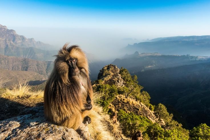
To maximize their efficiency, Geladas have developed a unique shuffling gait. They sit on their rumps—which are protected by thick callosities—and move along the ground by sliding their feet, plucking grass with their hands.13 Because their backsides are occupied by sitting, the traditional primate signals of sexual readiness have migrated to the chest. Both sexes possess a hairless patch of skin that turns a vibrant, pulsing red during peak hormonal cycles. In females, this patch is surrounded by a "necklace" of fluid-filled blisters during estrus, a clear signal to males across the grassland.
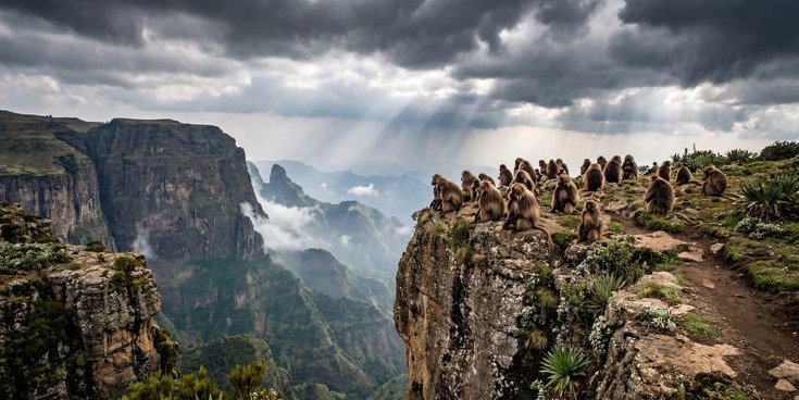
Gelada society is a marvel of multi-layered complexity. The basic unit is the reproductive unit or harem, consisting of a dominant male, several related females, and their offspring. These units aggregate into bands, and occasionally into herds of over 1,000 individuals. Living in such large groups requires sophisticated communication. The gurgling vocalizations of the Gelada are among the most complex of any non-human primate, featuring a rhythm and cadence that scientists believe is an evolutionary precursor to human speech. These sounds are particularly intense after a conflict; rather than the physical grooming seen in other monkeys, Geladas use long, complex vocal sequences to calm the troop and signal that peace has returned.
The Walia Ibex: The Guardian of the Cliffs
The Walia Ibex (Capra walie) is a mountain goat found nowhere else on earth. Its habitat is restricted to the highest, most inaccessible cliffs of the Simien range, usually between 2,500 and 4,500 meters. These animals are the masters of the vertical, possessing hooves with sharp edges and concave undersides that act as suction cups on the slick basalt.1
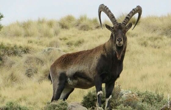
The Walia Ibex is sexually dimorphic. Males are robust, weighing up to 125 kilograms, with massive, backward-curving horns that can reach 110 centimeters in length. Females are smaller and more elusive, their chestnut-brown coats providing perfect camouflage against the rock. They are crepuscular, most active in the early morning and late evening, while spending the heat of the day resting in the shade of dense brush on the cliff ledges.
The population of Walia Ibex is critically small, estimated at approximately 500 individuals. Historically, they were found throughout the Simien Mountains, but human encroachment and livestock grazing have pushed them into the most remote eastern areas of the park.16 Their survival is a testament to the resilience of life in the highlands, but they remain vulnerable to habitat fragmentation and the encroachment of domestic goats, which compete for the same scarce forage.
The Ethiopian Wolf: The Red Shadow
The Ethiopian Wolf (Canis simensis) is the world’s rarest canid and Africa’s most endangered carnivore.6 With fewer than 500 adults remaining in the wild, the wolf is a ghost of the moorlands, appearing as a flash of russet fur against the golden grass.
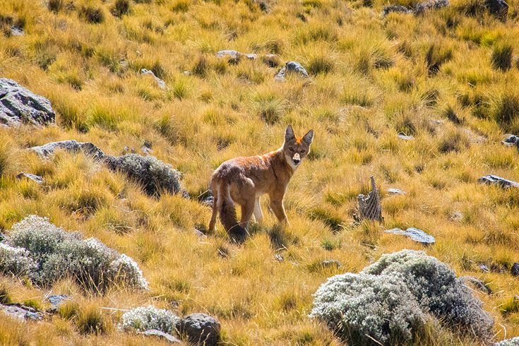
Unlike grey wolves or African wild dogs, the Ethiopian Wolf is a solitary hunter. Their diet consists almost entirely of highland rodents, specifically the giant mole-rat. Their physical features are finely tuned for this purpose: a long, narrow snout and widely spaced teeth allow them to snap up rodents from their burrows. While they hunt alone, they are social animals, living in packs of up to 13 individuals that cooperate to defend territory and raise pups.
The wolf is a "keystone predator," meaning its presence ensures the balance of the entire ecosystem. By controlling the population of moorland rodents, they prevent the overgrazing and degradation of the highland vegetation. However, their specialized nature makes them incredibly vulnerable. Habitat loss and diseases like rabies and canine distemper—often transmitted by domestic dogs from nearby communities—are constant threats to their survival.
Getting There: From the Capital to the Clouds
The transition from Addis Ababa to the mountains is easier than you might think. To get to the mountains, most people fly from Addis to Gondar. It is a short, one-hour flight that saves you a 12-hour drive.
- Gondar to Debark: From Gondar, it is a two-hour drive to the town of Debark, which is the gateway to the park.
- Permits and Fees: You must stop at the Park Headquarters in Debark to get your permits. For international visitors, the fee is roughly 90 Birr per day .
- The Mandatory Scout: Park rules require every group to hire an armed scout . These are local men who know the land perfectly. While they carry rifles, it is a traditional role meant to keep you safe from wildlife, and they are usually very friendly.
Trekking in the Simien Mountains is a journey of escalating drama. The air thins, the trees shrink, and the scale of the landscape expands until the horizon seems to shatter into a thousand basalt needles.
Phase 1: The Escarpment Edge (Sankaber to Gich)
The trek typically begins near Buyit Ras, a short drive from the park gate. The first few hours of walking lead toward Sankaber Camp (3,250m). The trail hugs the edge of the escarpment, providing a constant, dizzying view into the abyss. It is here that the smell of the highlands first hits—a mixture of wild herbs, woodsmoke from distant villages, and the sharp, clean scent of the giant heath.
From Sankaber, the path follows the ridge before dropping into the Koba Valley. The highlight of this day is the Jinbar Waterfall. This is not a gentle cascade; the Jinbar River plunges 500 meters vertically into the Gich Abyss. Standing on the viewpoint opposite the falls, the trekker watches as the water turns to mist long before it hits the canyon floor.
Gich Camp (3,600m) is situated on a broad, open plateau. The vegetation here is dominated by low-lying grasses and the beginning of the lobelia fields. As the sun sets, trekkers often make the short climb to the Kedadit viewpoint to watch the Gelada monkeys retreat from the plateau to the safety of the cliff caves for the night.
Phase 2: The Spires of Imet Gogo
The second phase of the trek centers on Imet Gogo (3,926m). This is widely considered the most spectacular viewpoint in the entire Simien range. Imet Gogo is a promontory that juts out from the main escarpment, offering a 360-degree view of the "Chessboard of the Gods". From here, the jagged peaks of the lowlands appear like a petrified sea, and the sheer cliffs of the main plateau stretch out in either direction.
The air at nearly 4,000 meters is noticeably thin. Every step requires a deliberate breath, and the silence is so profound that the rustle of a raven’s wing can be heard from a hundred meters away. The path then continues toward Inatye (4,070m), passing through a forest of giant hazel and open grasslands where the Ethiopian Wolf is sometimes seen hunting in the early afternoon.
Phase 3: The Highland Frontier (Chennek to Buhait)
Chennek Camp (3,620m) is the most vibrant of the campsites, situated at the base of Mount Buhait and surrounded by fields of giant lobelia. Because it is accessible by road, it is less isolated than Gich, but it offers the best wildlife viewing in the park. The Walia Ibex are regular visitors here, often seen grazing on the rocky slopes just above the tents.
The climb from Chennek to the Buhait Pass (4,200m) is one of the most physically demanding sections of the trek. The trail is steep and rocky, but the reward at the summit is the first clear view of Ras Dashen across the Meseha Valley. For many, the sight of Ethiopia’s highest peak—a massive, dark buttress of rock often dusted with frost or light snow—is the emotional peak of the journey.
Phase 4: The Roof of Africa (Ras Dashen)
Summiting Ras Dashen (4,533m) requires an early start from Ambiko Camp. The final ascent is not technical, but it is a test of endurance. The path follows a ridge crest overlooking a vast valley, eventually leading to a pile of rocks that marks the highest point in the country. At this altitude, the world feels raw and unfinished. The horizon is a jagged line of basalt, and the sky is a deep, bruised blue that only occurs at high elevations.
Climate and Seasonality: The Window of Opportunity
The Simien Mountains do not follow the four seasons of the northern hemisphere. Instead, the climate is defined by the "Dry" and "Wet" seasons, influenced by the movement of the Intertropical Convergence Zone.
Seasonal Trekking Conditions
To plan a successful expedition, you must align your journey with these five distinct windows of opportunity:
The Post-Rain Bloom (October – November)
The "Early Dry" season is arguably the most stunning time to visit. Having just emerged from the heavy rains, the landscape is a vibrant, lush green. Hikers will find wildflowers in full bloom and enjoy excellent trekking conditions before the dust of the dry season sets in.
The Peak Dry Window (December – February)
This is the height of the trekking season. The skies are at their clearest, offering the most reliable views of the dramatic escarpments. However, the lack of rain means the air becomes increasingly dusty and the landscape loses its verdant color, taking on a more arid, golden hue.
The Shoulder Season (March – May)
Conditions remain generally good, though this period introduces intermittent showers. These rains serve a practical purpose for the traveler: they settle the dust from the preceding months, sharpening the views, though you should be prepared for sudden changes in weather.
The Main Wet Season (June – August)
Trekking during these months is generally discouraged and conditions are rated as poor. Heavy, relentless rains make mountain roads prone to failure and often shroud the famous vistas in a thick, impenetrable mist.
The Late Wet Transition (September)
As the rains begin to taper off, the mountains undergo a rapid transformation. Visibility returns with exceptionally clear air, and the wildflower display reaches its absolute peak. It is a brief but rewarding "good" window for those who don’t mind the occasional lingering shower.
The temperature in the Simiens is relatively stable throughout the year due to its equatorial position, but it fluctuates wildly within a single 24-hour period. Daytime temperatures average around 18°C (64°F), which can feel much hotter under the intense high-altitude sun. However, as soon as the sun dips behind the escarpment, the temperature plummets, often dropping below freezing at campsites like Gich and Chennek. Hypothermia is a real risk for the under-prepared, making high-quality gear essential for survival.
Gear and Preparation: The Explorer’s Toolkit
Trekking the Simiens is an exercise in layering. You begin the day in a t-shirt as you climb through the sun-drenched valleys and end it in a heavy down jacket as the frost begins to form on your tent.
Essential Gear List
- Footwear: Broken-in hiking boots with good ankle support are mandatory. The terrain is a mix of loose basalt scree, muddy valley floors, and steep rocky paths.
- Sleeping Bag: A bag rated to at least -5°C (23°F) is necessary. While some lodges provide gear, the quality of rental bags in Debark can be variable.
- Protection: A wide-brimmed hat and high-SPF sunscreen are critical. At 4,000 meters, the atmosphere provides significantly less protection from UV radiation.
- Water: Purification tablets or a high-quality filter (like a LifeStraw or Grayl) are essential. While water is available at campsites, it must be treated before consumption.
- Clothing: Moisture-wicking base layers, a fleece mid-layer, and a waterproof/windproof outer shell. Waterproof gear is recommended even in the dry season, as afternoon showers can occur in the high peaks.
Health and Altitude
Altitude sickness, or Acute Mountain Sickness (AMS), is the primary health concern. Addis Ababa sits at 2,350 meters, which provides a good baseline for acclimatization, but the rapid jump to 3,600 meters at Gich can trigger symptoms. Trekkers are advised to "climb high and sleep low" whenever possible and to maintain high levels of hydration. Diamox is often carried by trekkers as a prophylactic, but it should only be used after consultation with a physician.
The Future of the Highlands: Conservation and Community
The Simien Mountains National Park is a UNESCO World Heritage site, but this status has been threatened in the past due to human encroachment. The future of the park depends on the integration of conservation with the needs of the local Amhara communities.
Community-Based Tourism
The park management has shifted toward a model of community tourism.6 This includes:
- Local Employment: Scouts, guides, cooks, and muleteers are all drawn from the surrounding villages, ensuring that the economic benefits of trekking remain in the region.
- Infrastructure: Projects that provide clean water and schools to the villages help reduce the pressure on the park’s natural resources.
- Grazing Strategies: Efforts are underway to limit livestock movement in core wildlife ranges, particularly in areas where the Ethiopian Wolf and Walia Ibex are most active.
By booking through trusted local operators and staying in community-managed lodges, trekkers directly contribute to the preservation of this unique ecosystem.
Your journey starts here
The Simien Mountains are more than just a destination; they are a challenge that rewards you with views you will never forget. We recommend working with reputable local agencies, who employ local guides and support the mountain communities .
Safety Update: As of early 2026, the Simien Mountains National Park is open and generally safe for travelers, especially on organized tours. Because the situation in the Amhara region can change, it is best to fly into Gondar rather than driving overland from other regions. Always check the latest updates.
Do you have few days in Addis? Then, here are seven must see adventures in Addis. Alternatively, do you want to destinations not too far from Addis? Then you'd love this journey through millennia all within a few hours' drive from the city.
Do you want to explore other exciting destinations? Do you crave adventure, wild landscapes, and the thrill of spotting something truly rare, then the Bale Mountains are calling your name.
Are you ready to walk among the "Chess pieces of the gods"? Connect with our community, check current weather guides, and get advice from people who have already stood on the roof of Africa. Let's get you to the trail.